Remote Sensing e Spatial Data Science Lab
The Remote Sensing e Spatial Data Science Lab combines Remote Sensing (RS) and Spatial Data Science (SDS) methodologies to develop innovative tools for analyzing and automatically extracting information in interdisciplinary cultural heritage research. Its applications range from archaeological investigations to risk assessment, site monitoring, and conservation strategies.
By integrating RS and SDS, the lab enhances the efficiency of data extraction, improves result interpretation, and fosters the creation of repeatable tools and procedures. These methodological advancements contribute to a deeper understanding of the human past while supporting sustainable cultural heritage management and preservation efforts.
Methodologies
Remote Sensing (RS) leverages data acquired from active and passive sensors across multiple scales—from satellites to drones—integrating image fusion, feature extraction, statistical analysis, historical data studies, and Big Data processing. This approach creates a sophisticated information framework for extracting insights, building models, and developing algorithms tailored to archaeological research, ancient landscape studies, conservation efforts, and risk assessments of cultural heritage, both natural and human-induced. Additionally, the laboratory features a specialized unit focused on marine remote sensing, dedicated to exploring the interaction between natural and cultural resources in underwater environments.
Spatial Data Science (SDS) focuses on identifying the most effective models and methods for collecting, processing, and analyzing remote sensing and spatial data. Its primary goal is to uncover both known and previously unknown patterns, enhancing knowledge discovery. This process is structured around three main macrosectors:
- Geographic Information Systems,
- Creation and management of spatial DBMS and Big Data Systems,
- Spatial data analytics. - This encompasses a wide range of techniques, from geovisualization to broader data science methodologies, including statistical analysis, machine learning, and ensemble methods. These approaches are adapted to a spatial context, enabling a deeper evaluation of their effectiveness in analyzing and interpreting spatial data,
Research lines
Remote sensing, Big data analysis and artificial intelligence for the study of the human past, landscape archaeology and cultural heritage risk analysis
- Analysis of spectral properties from remotely sensed data for the identification of archaeological proxy indicators with special reference to crop-marks.
- Development of procedures for the fusion of active and passive remote sensing data (satellite, airborne, geophysical) for the creation of predictive models to support preventive archaeology.
- Development of processing and post-processing methodologies of active remote sensing data (LiDAR and SAR) for the analysis of microtopographic variations for the identification of archaeological features and the study of ancient landscapes.
- Development of machine learning methods from multispectral remote sensing data (satellite and drone) for the automatic extraction of features and patterns of archaeological interest and for the analysis of natural and anthropic risk factors.
- Hyperspectral imaging from aircraft and satellite for geoarchaeological and environmental archaeology applications.
- Multi-temporal analysis of medium- and high-resolution Big Data satellites for change detection, spatio-temporal pattern detection for the identification and evaluation of risk factors of cultural and natural heritage.
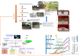
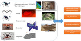
Multiscale methodologies of integration and fusion of close-range remote sensing, sensoristics and in situ imaging techniques for the conservation and monitoring of the built and artistic heritage
- Drone-Borne Surveying and Imaging – Designing and applying drone-based techniques for documenting, analyzing, and diagnosing the preservation state of archaeological and monumental sites.
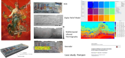
- Data Fusion and Feature Extraction – Integrating datasets from various imaging techniques (thermal infrared, high-frequency georadar, digital models) to identify and assess degradation pathologies in architectural surfaces and wall paintings.
- Multiscale Environmental and Microclimatic Monitoring – Employing indoor and outdoor approaches to study environmental conditions affecting works of art.
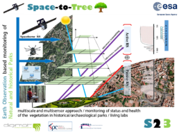
- Integrated Earth Observation and Multi-Platform Technologies – Combining satellite, drone, sensor, and in situ imaging for monitoring and managing tree heritage in archaeological sites and historic urban parks.
- Seismic Risk Analysis of Historical Structures – Developing operational protocols using passive single-station techniques to assess the seismic vulnerability of leaning architectural structures.
Underwater acoustic remote sensing for in situ research on underwater cultural heritage
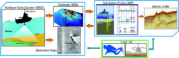
- Integrated Underwater Data Analysis – Utilizing multibeam bathymetric measurements, backscatter data, and seismic data to study, monitor, and manage cultural and natural resources in underwater environments.
- 3D Modeling of Underwater Archaeological Features – Developing procedures that integrate high-resolution bathymetric data with underwater digital photogrammetry to create detailed 3D models of submerged historical and archaeological sites. feature storico-archeologiche sommerse.
- Land-Sea Archaeological Detection – Combining multibeam bathymetric data with LiDAR in marine-coastal environments to identify historical and archaeological targets at the land-sea interface.
- Sub-Bottom Archaeological Mapping – Conducting integrated seismic and electrical tomography analyses to detect and map buried archaeological and topographical features in the shallow subsurface.
Spatial Data Science
- Exploratory Spatial Data Analysis (ESDA) – Extracting significant spatial patterns and uncovering new explanatory relationships across diverse archaeological case studies.
- Spatial Visualization Methods – Developing techniques for effectively representing spatial data to enhance interpretation and analysis.
- Geocomputation and Decision Support Systems – Creating predictive models for archaeological research and heritage management through advanced computational methods.
- Spatial DBMS and Big Data Systems – Implementing database management and big data frameworks to integrate archaeological and cultural heritage data with remote sensing information for improved analysis and decision-making.
Research Instrumentation and Infrastructure
The laboratory's expertise and equipment are an integral part of the MOLAB platform of the ERIHS (European Research Infrastructure for Heritage Science) infrastructure.
MOLAB provides competitive, free access to a suite of portable, non-invasive instruments for heritage science research. Italian researchers can access these resources through the E-RIHS.it node, supported by MUR, while European researchers benefit via the IPERION HS project, funded by the European Commission (2020-2023). Additionally, the laboratory has received SHINE funding (PON-IR) to enhance ERIHS.it nodes, facilitating the development of AIRLAB—a mobile drone facility equipped with active and passive sensors for remote sensing data acquisition.
AIRLAB, part of the REMOLAB infrastructure, a platform on drones for remote sensing data acquisition using active and passive sensors.
IRPAC, Infrastruttura Tecnologica e di Ricerca per lo Studio del Passato Umano, la Conservazione e Gestione del Patrimonio Culturale (PO-FESR Regione Basilicata 2012-2020).
Staff Remote Sensing e Spatial Data Science Lab
Nicodemo Abate

Alessia Allegrini

Antonio Minervino Amodio
Marilisa Biscione

Maria Danese

Dario Gioia
Fabrizio Terenzio Gizzi
Ivana Guidone

Giulio Lucarini

Nicola Masini
Pasquale Merola
Salvatore Piro

Maria Rosaria Potenza

Maria Sileo

Crescenzo Violante
Associati al Remote Sensing e Spatial Data Science Lab
How to contact us
resdatalab@ispc.cnr.it
Projects and Research activities
Space-to-Tree: Earth Observation based monitoring of Natural and historical Park. European Space Agency – Avviso ARTES IAP-5G for L’ART Demonstration Projects [2020-2022].
H-WITHIN| HERITAGE WITHIN. Programma Cross Sectoral Strand Action INNOVLAB – Bridging culture and audiovisual content through digital. Grant agreement ID: 614719 [2020 – in corso].
SMACH| Sustainable Management of Cultural Heritage in the Balkans in response to Climate Change. Best practices for adaptation and intercultural cooperation. Central European Initiative (CEI). Know-how Exchange Programme (KEP) [2021-2022].
FOOPROMAG | The earliest food production in the Eastern Maghreb: How? When? Where?
Progetto bilaterale tra CNR ISPC e ISAM Kasserine, Université de Kairouan, Tunisia [2021-2022].
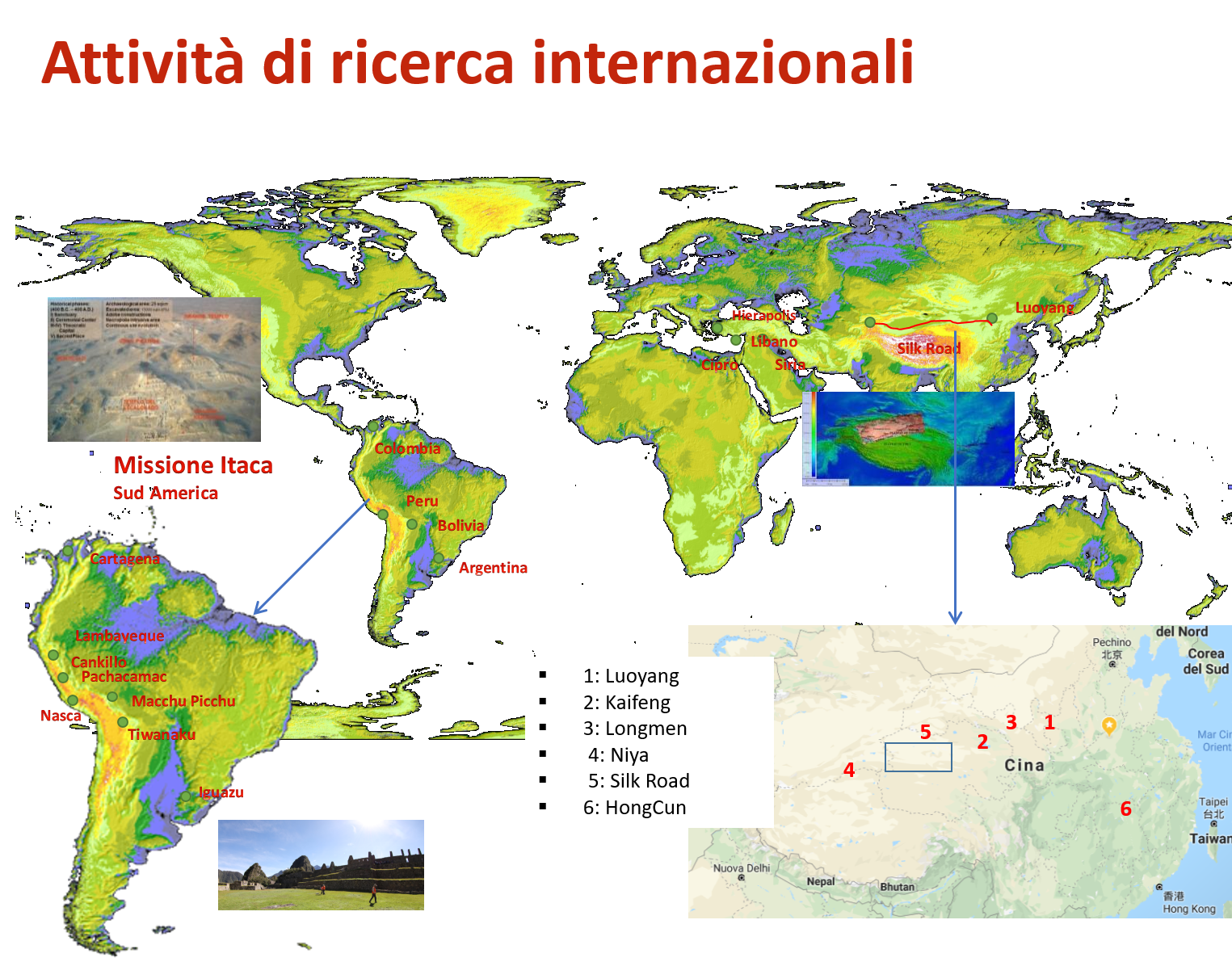
Missione internazionale ITACA. Progetti scientifici in Sudamerica per l’archeologica preventiva (Peru e Bolivia) e la protezione del paesaggio (Peru e Argentina) con tecnologie e metodologie di archeogeofisica, telerilevamento e GIS, diagnostica per la conservazione (Colombia). [2008-in corso].
MeSAP. Progetto archeologico multidisciplinare italo-libanese a Maasser El-Shouf /Qalaat el-Hosn (Libano) per la ricostruzione dell’ambiente naturale e antropico nell’antichità, con particolare attenzione allo sfruttamento delle risorse naturali con metodologie e tecnologie di telerilevamento e GIS [2018 – in corso].
Missione internazionale CNR (ISPC e IMAA) e CAS. Studio del passato umano nella regione dell’Henan ed altre regioni della Cina (Xinjiang) dalla dinastia Han a quella Ming.
Farafra Oasis Archaeological Project, Egypt (ISMEO e CNR ISPC). Indagine delle dinamiche socio-culturali e dei modelli di popolamento delle regioni del Deserto Occidentale Egiziano e dei rapporti tra queste e la Valle del Nilo durante l’Olocene.
Basilicata Heritage SmartLab. POR FESR Basilicata 2014-2020
Progetto di potenziamento della Infrastruttura di Ricerca IRPAC – Infrastruttura Tecnologica e di Ricerca per lo Studio del Passato Umano, la Conservazione e Gestione del Patrimonio Culturale [2021-2023].
Tecnologie geofisiche e geo-ambientali per il monitoraggio, la fruizione e la conservazione di beni archeologici sommersi. Progetti di ricerca in convenzione con il Parco Archeologico dei Campi Flegrei, resp. Crescenzo Violante [2020-2023].
For further information on ISPC research activities click the button.
Main collaborations
Istitutions
- Agenzia Spaziale Tedesca
- Associazione Internazionale di Studi sul Mediterraneo e l’Oriente (ISMEO)
- Chinese Academy of Sciences, Pechino
- CNR IMAA – Istituto di Metodologie per l’Analisi Ambientale
- CSIC IGEO – Instituto de Geociencias, Spagna
- European Space Agency (ESA)
- Henan Academy of Science a Zheng Zhou, Cina – Center for Earth Observation and Digital Earth
- Institut National du Patrimoine, Tunisie
- Ministero Affari Esteri Italiano
- Ministry of Tourism & Antiquities, Egypt
- Parco Archeologico dei Campi Flegrei, Campania
- Basilicata Region
Universities
- Cyprus University of Technology (CUT)
- Pontificia Università Cattolica del Perù, Lima
- Università degli Studi della Basilicata
- Università del Minho, Portogallo
- Università di Cartagena, Colombia
- Università Politecnica di Valencia, Spagna
- Universitat de les Illes Balears, Palma di Maiorca
Main publications
C. Broodbank, G. Lucarini (2019). The Dynamics of Mediterranean Africa, ca. 9600-1000 bc: An Interpretative Synthesis of Knowns and Unknowns. “Journal of Mediterranean Archaeology” 32(2): 195-267.
M. Danese, M. Sileo, N. Masini (2018). Geophysical Methods and Spatial Information for the Analysis of Decaying Frescoes. “Survey in Geophysics”. Vol.39(6), pp. 1149-1166.
M. Danese, N. Masini , M. Biscione, R. Lasaponara (2014). Predictive modeling for preventive Archaeology: overview and case study. “Central European Journal of Geosciences”. 6(1) 42-55,
S. Festuccia, S. Di Tonto, M. Como, A. Ferraro (2013). The Contribution of GIS Technology to Archaeological Research: the case of the Protopalatial site of Monastiraki (Crete), in SOMA 2012 Identity and Connectivity: Proceedings of the 16th Symposium on Mediterranean Archaeology, Firenze, L. Bombardieri et alii (Eds.), BAR 2013 (1), 389-396.
S. Festuccia 2012, Urbanization in Syria between the Late Bronze Age and Early Iron Age: an Overview, Università degli Studi Suor Orsola Benincasa, Napoli, ISBN 978-88-96055-37-3.
F.T. Gizzi, J. Kam, D. Porrini, Time windows of opportunities to fight earthquake under-insurance: evidence from Google Trends. “Humanities & Social Sciences Communites” 7, 61 (2020).
Lasaponara R., Masini N. (2018). Space-Based Identification of Archaeological Illegal Excavations and a New Automatic Method for Looting Feature Extraction in Desert Areas. Surv Geophys (2018).
R. Lasaponara, N. Masini (Eds) 2012, Satellite Remote Sensing: a new tool for Archaeology, Springer, Verlag Berlin Heidelberg, Series: “Remote Sensing and Digital Image Processing”, Vol. 16, 364 p. 150 illus., 88 in color, ISBN 978-90-481-8800-0
L. I. Manfredi, S. Festuccia , P. Merola et alii (2020). Integrated multi scale archaeological analysis in Béni Mellal-Khenifra District (Morocco): the case of the Fortress of Ighram Aousser. “Archeologia e Calcolatori” 31 (1) 97-120,
L. I. Manfredi, S. Festuccia (Eds) 2016, AOUAM I. Rapport préliminaire de la première campagne de prospection et de fouille dans la zone minière du Jebel Aouam, Bradypus, Bologna, ISBN 978-88-98392.
Masini, N., Lasaponara, R. (2020) On the Reuse of Multiscale LiDAR Data to Investigate the Resilience in the Late Medieval Time: the Case Study of Basilicata in South of Italy. “Journal of Archaeological Method and Theory”, Springer.
N. Masini, R. Lasaponara (2020). Satellite and close range analysis for the surveillance and knowledge improvement of the Nasca geoglyphs. “Remote sensing of environment”. Volume 236, January 2020, 111447
M. Sileo, F. T. Gizzi, A. Donvito, R. Lasaponara, F. Fiore, N. Masini (2020) Multi-Scale Monitoring of Rupestrian Heritage: Methodological Approach and Application to a Case Study, “International Journal of Architectural Heritage”.
C. Violante (2020), Acoustic remote sensing for seabed archaeology. “Proceedings of the International Conference on Metrology for Archaeology and Cultural Heritage”. Trento, Italy, October 22-24, 2020, 21-26. ISBN: 978-92-990084-9-2.
C. Violante, (2018) A geophysical approach to the fruition and protection of underwater cultural landscapes. Examples from the Bay of Napoli, southern Italy. In: Aveta, A., Marino, B.G., Amore R. (eds.), La Baia di Napoli. Strategie per la conservazione e la fruizione del paesaggio culturale. V. 1, 66-70. Artstudiopaparo, ISBN: 978-88-99130.